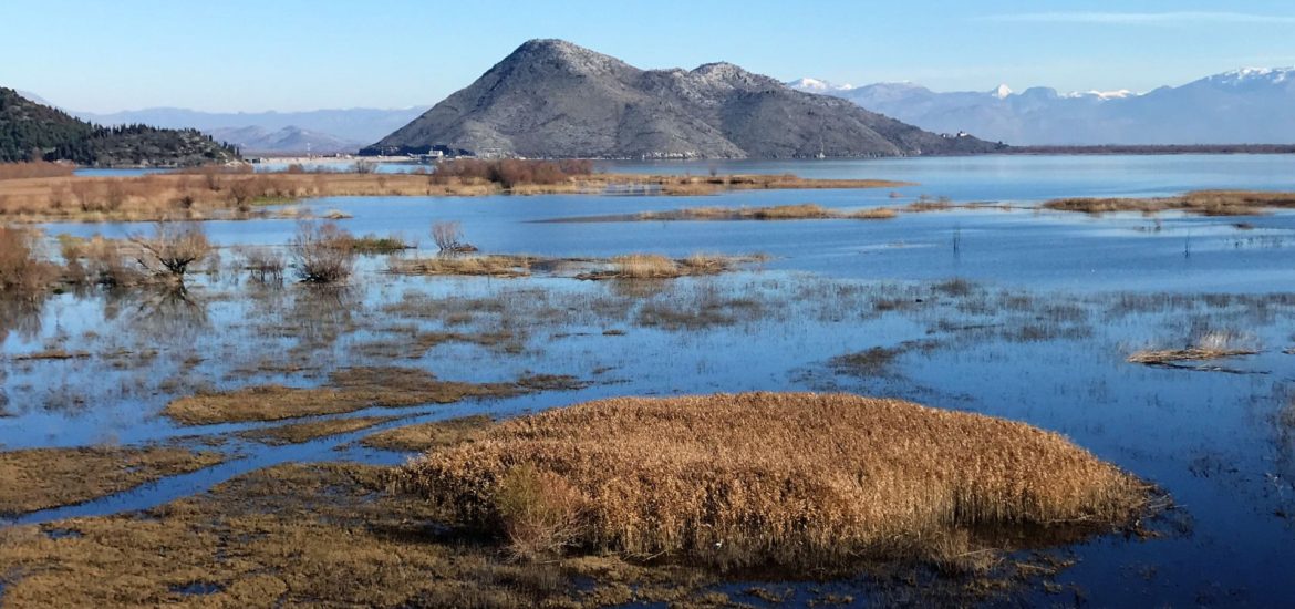
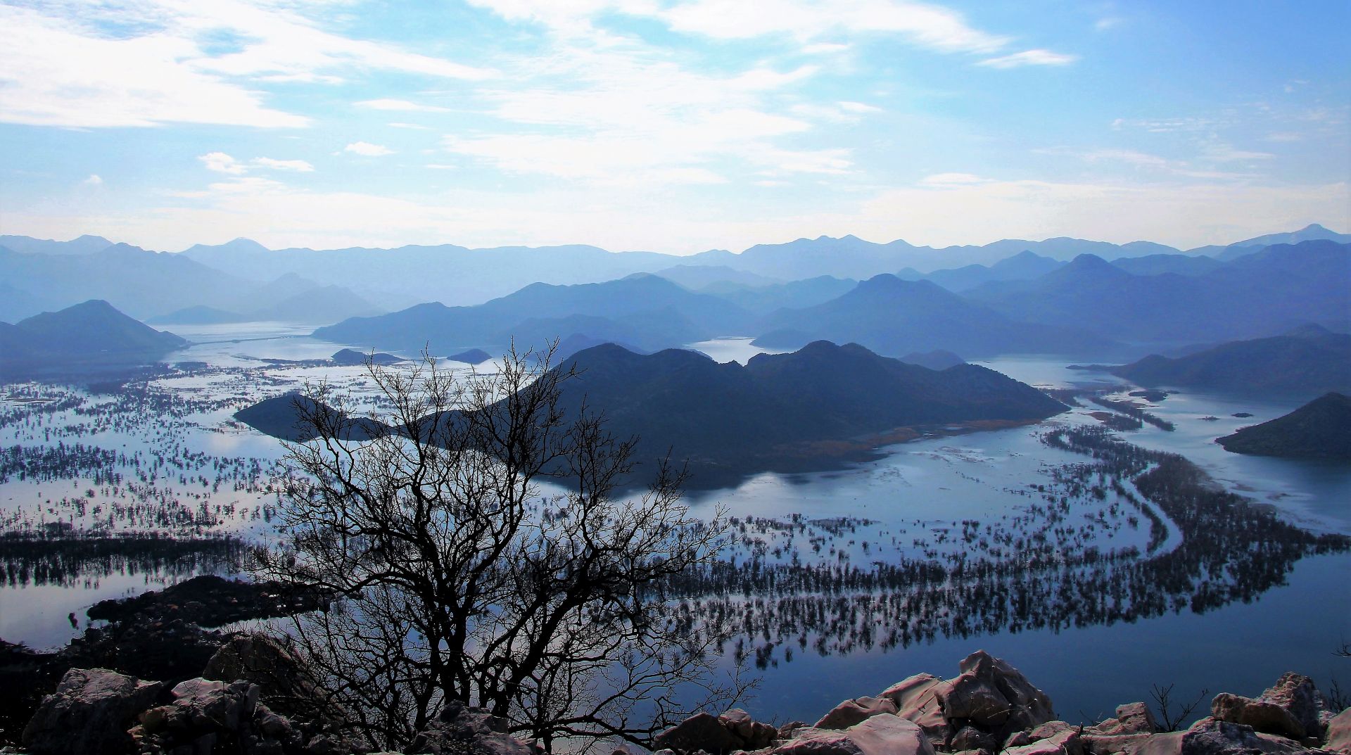
Early spring is the most beautiful time to make a road trip through the wetlands of Skadar Lake. From time to time, the water level may be quite high in that period. It is a special experience to see the flooded areas in the northern part of the Lake. The landscapes are fantastic and the views of the wetlands vary from day to day.
From Podgorica, you can make an attractive round tour that is approximately 80 km long, with the possibility to make several detours to nearby fishing villages on the Lake.
The Route
Leave Podgorica in the direction of Virpazar. If you want to make a detour to the historical settlement of Žabljak Crnojevića, take the bypass road around Golubovci and then the local road (turn right at the appropriate brown signpost near Vukovci and pass the bridge). Back on the main road, you will pass the fishing village of Vranjina and the Lesendro fortress. Take a break in Virpazar, walk around or make a boat excursion (if available).
From Virpazar, cross the highway and take the road uphill in the direction of Rijeka Crnojevića. On the top of the hill is a beautiful panorama point. This road offers great views of Skadar Lake and the surrounding karst mountains. On your way, you can stop and make a hiking tour to the village of Poseljani (yellow signpost on the right side of the road, 15 km from Virpazar). If you don’t like hiking, you can also take the new asphalt road downhill (signpost provided) to the village.
Rijeka Crnojevića is a perfect place for sightseeing and lunch. Driving further along the road towards the highway Cetinje-Podgorica, you will pass Pavlove Strane, one of the most beautiful viewpoints in Montenegro.
If you have enough time and you are not afraid of winding, narrow and unprotected roads, you can make two interesting detours. The first one begins in the village of Drušići; follow the signpost to Prevlaka (turn right). This is a nice village at the end of a small peninsula in the northern part of Skadar Lake. Even more interesting is the detour to Karuč and Dodoši: turn right in the village of Rvaši and follow the narrow road, full of potholes, high above the lake. Make a stop in Karuč, an old fishing village (drive downhill at the signpost). Continue to Dodoši, another charming village on the Lake. Both detours are dead end roads.
By the way, you can also extend this detour. Driving back from Dodoši, turn sharp right uphill at the big square called Bobijaški Trg. A short stretch of the road is macadam (also suitable for passenger cars – dotted line on the map) and then the road runs through the village of Briđe back to the main road, from where you will soon reach Podgorica.
The Road Trip
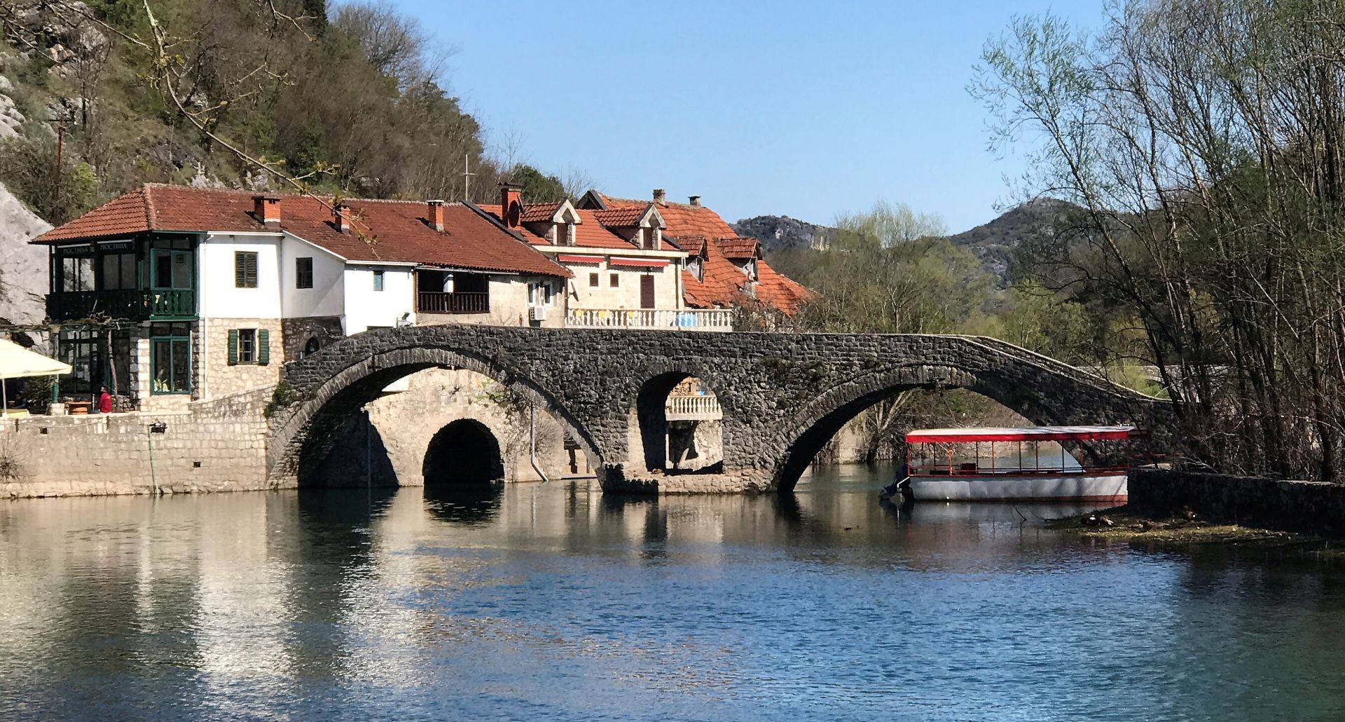
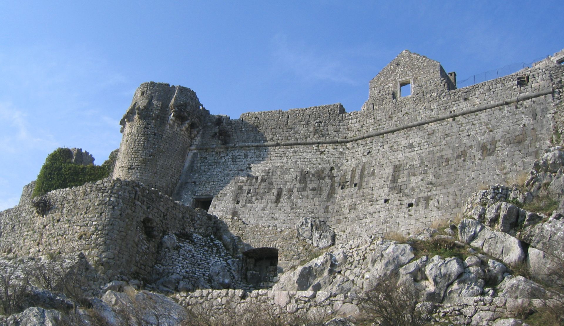
If you would like to visit Žabljak Crnojevića, once capital of the Crnojević dynasty, I recommend you to make a detour to this ancient fortress, situated on the top of a hill above Skadar Lake. At a distance of 15 km from the capital, it gives you the opportunity to see ‘Old Montenegro’. Once arrived, you can park your car near the old Turkish bridge and take a walk uphill to the castle that seems totally abandoned.
It is assumed that this fortress was built in the 10th century, when the Romans ruled these areas. During the Crnojević dynasty, in the 15th century, it resembled a Venetian fortification. At that time, the city consisted of 300 houses. During the period of Ottoman rule, it was one of the most important strongholds of the area, around which fierce battles took place.
The fortress itself has huge walls, two meters wide, and up to 15 meters high. Climbing the stairs and entering the gate, you will pass through a narrow and arched corridor. Now you can see the ruins of the Church of St. George, housing and military facilities, a warehouse and a water tank. The view of the flooded wetlands and the mysterious lake is breathtaking. Far away, you can still see the mountains covered with snow.
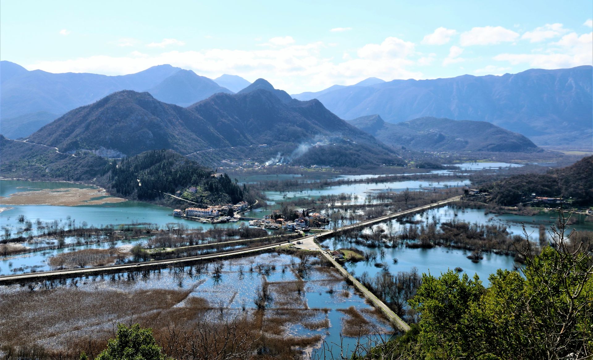
Back on the highway, you can continue the tour to Virpazar. On your way, you will pass the picturesque fishing village of Vranjina that was once located on an island. It is flooded during the winter and it is clear that the traditional boats called ‘čun’ – in early times the only means of transportation – are still popular in this village, as most inhabitants are fishermen.
Passing the dam across the lake, you will see the Lesendro fortress on your left side. This fortress was built by the Montenegrin ruler Petar II Petrovic Njegoš in 1832. It was also called “Key of Skadar Lake”, as it was meant to ensure safe trade and fishing. Unfortunately, it was conquered by the Turks in 1843.
As Skadar Lake is an international bird reserve, you will see many water birds during your trip: herons, gulls, cormorants and maybe even pelicans.
You will soon reach Virpazar, the centre of the Crmnica region. Take a walk, admire the old bridge and the cozy houses. Although Virpazar is a quiet place off-season, in summer it looks like a beehive, as it is the starting point for boat excursions.
Virpazar was first mentioned in 1242. The Turks conquered it in the 15th century. In 1478, they built the Besac castle, which still stands above the village. As Vir was an important trading centre, the word ‘Pazar’ (meaning ‘market’) was added to its name, which resulted in the name Virpazar (‘Vir-marketplace’). Virpazar is also famous for its uprising in 1941. A war monument can be seen on a rock in the centre of the village.
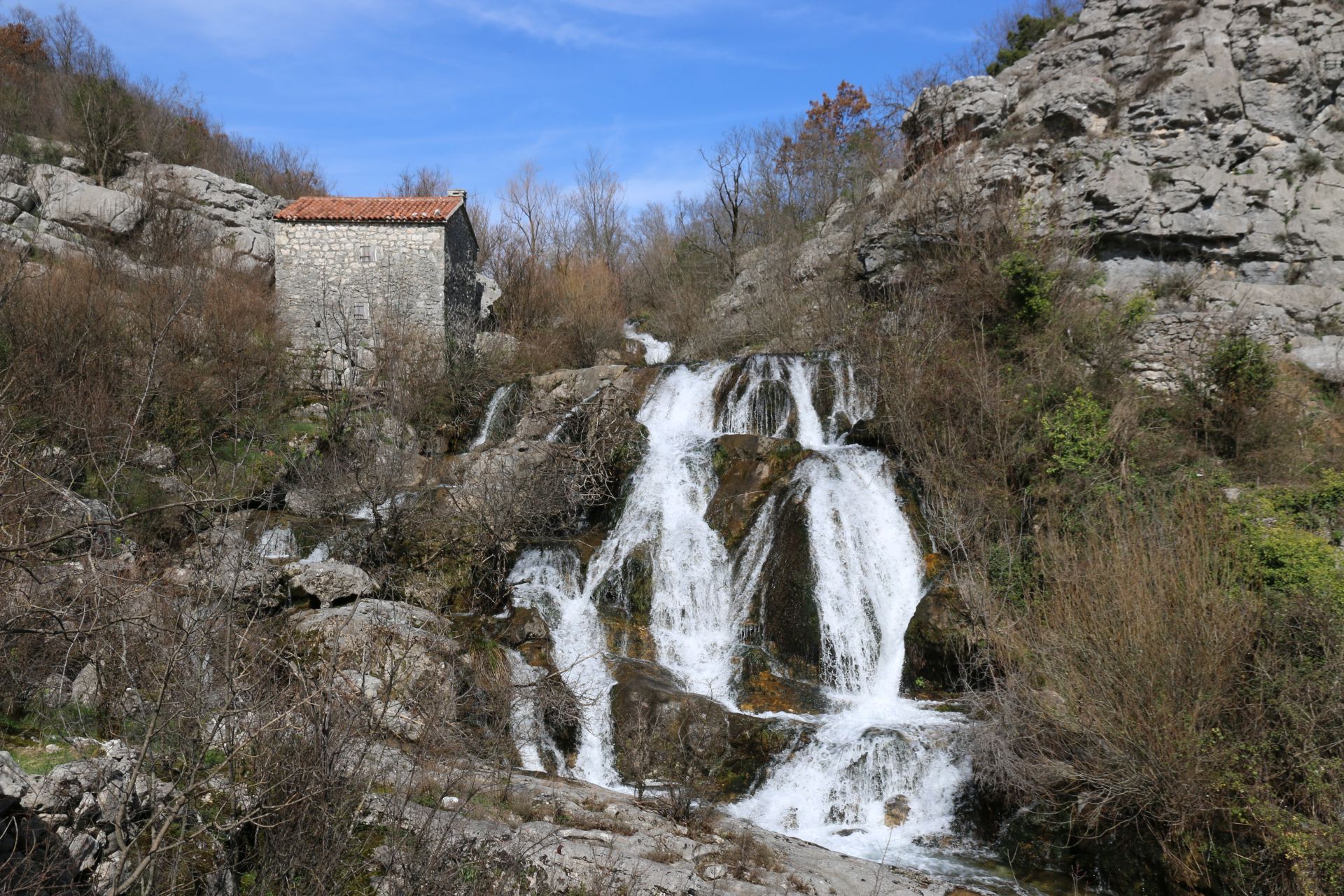
When you leave Virpazar, cross the main road and continue uphill in the direction of Rijeka Crnojevića. This narrow and winding road offers – apart from beautiful views of the Lake – many interesting karst landscapes. On the top of the hill is a panorama point (on the right side of the road). Soon (after 15 km) you will see a yellow signpost on the left side of the road, showing you a trail downhill. Here you can descend – along a picturesque brook – to Poseljani (a 30 minutes’ walk). With its authentic architecture, stone mills and arched bridges, this village is a secret treasure of the Skadar Lake region.
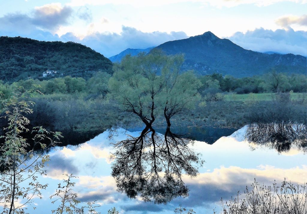
The road runs further, above the Lake and through the mountains, to Rijeka Crnojevića. This charming village has only a couple of hundred inhabitants. The picturesque arc-shaped bridge is a popular photo motive. The promenade – with several pubs and restaurants – is attractive, and many ruinous houses have been renovated. In the summer season, tourism blooms in Rijeka Crnojevića. In springtime, the level of the Crnojevića river and Skadar Lake itself is quite high, and the emerald green color is amazing. If the water level is very high, the quay can be completely flooded with hardly enough space under the bridge to pass with a traditional ‘čun’.
From Rijeka Crnojevića, follow the road in the direction of the highway Cetinje-Podgorica. On your way, you will see one of the most beautiful panoramas in Montenegro, Pavlova Strana. Make a photo stop and enjoy the view!
Arriving in the village of Drušići, you will see signposts to Prevlaka (turn right). This detour leads through an interesting landscape to the last settlement on this dead end road: Prevlaka, a lively village with a big church and many new houses.
Turn back to the junction and continue to Rvaši. You can make another beautiful detour by turning right to the villages of Karuč and Dodoši. On your way (between Karuč and Dodoši), you can take a break on a large square (Bobijaški Trg), where you have a magnificent view of the lake.
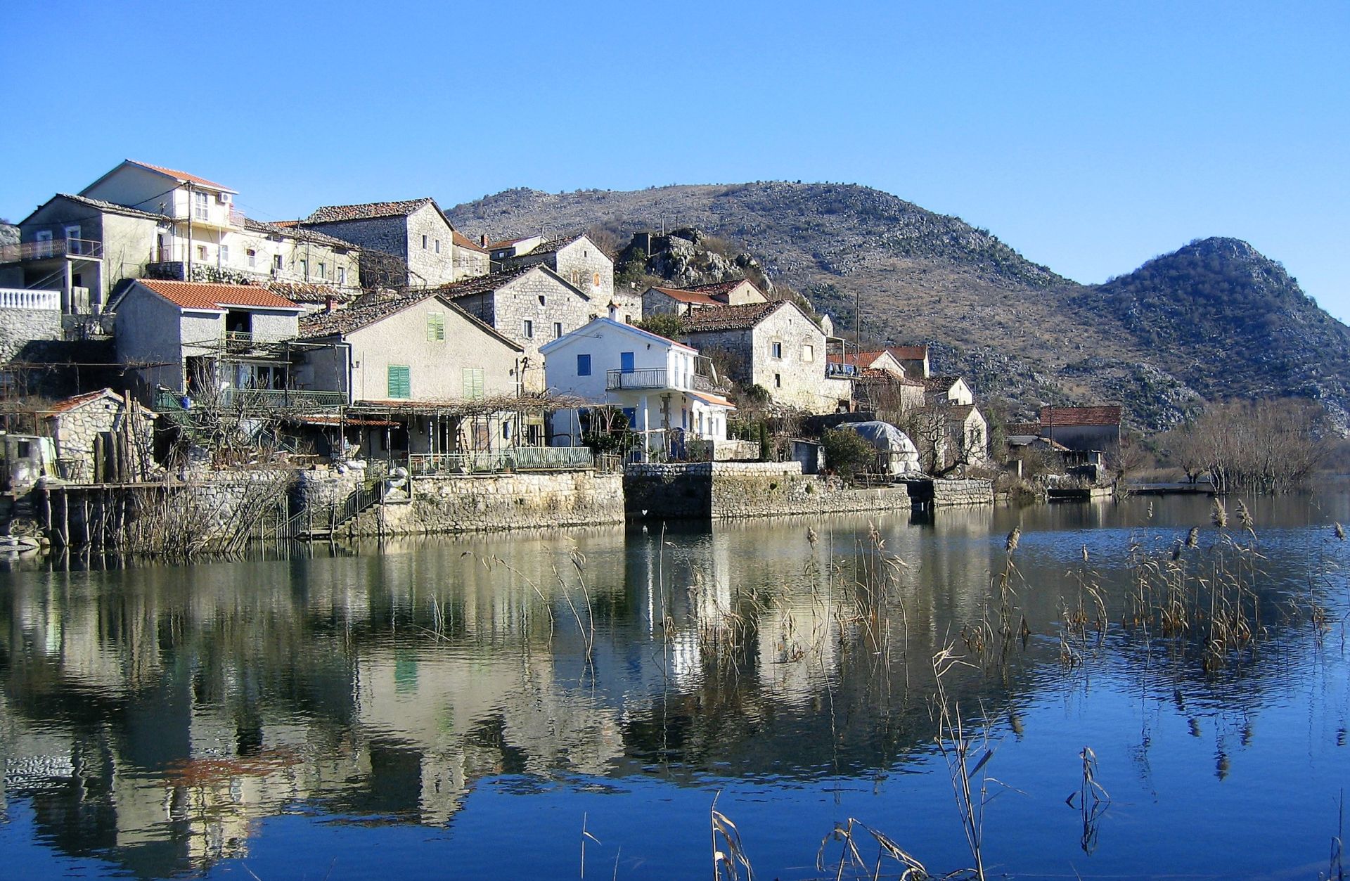
Continue to Karuč; turn right at the signpost and take the road downhill. Karuč is a picturesque fishing village nestled around a small cove. On the top of a hill on the left side is a ruined house, which was once the winter residence of Sveti Petar Cetinjski.
The narrow road continues, high above the lake, to Dodoši, an old fishing village at the foot of Mount Bobija. This is, in my opinion, one of the most beautiful parts of Skadar Lake National Park. In the winter period (and early spring), it is surrounded by water from all sides. At the end of the village is a low wooden bridge over the Karatuna river, which leads to a less known part of Skadar Lake, Malo Blato (in translation: Little Mud). In summer, you can pass the bridge by foot and walk to Žabljak Crnojevića (3.3 km).
Do you want to see more beautiful landscapes and views? In that case, you can extend this detour. Driving back from Dodoši, turn sharp right uphill at the big square called Bobijaški Trg. A short stretch of the road is macadam (also suitable for passenger cars) and then the road continues through the village of Briđe. There are several hamlets with beautiful stone houses along this route and the narrow road often runs in between old dry-stone walls. Finally, you will reach the highway and soon you will be back in Podgorica.
I am aware that our movements are still limited due to the corona measures, but I do hope that the situation will improve soon. Anyway, this tour is also beautiful in other seasons!
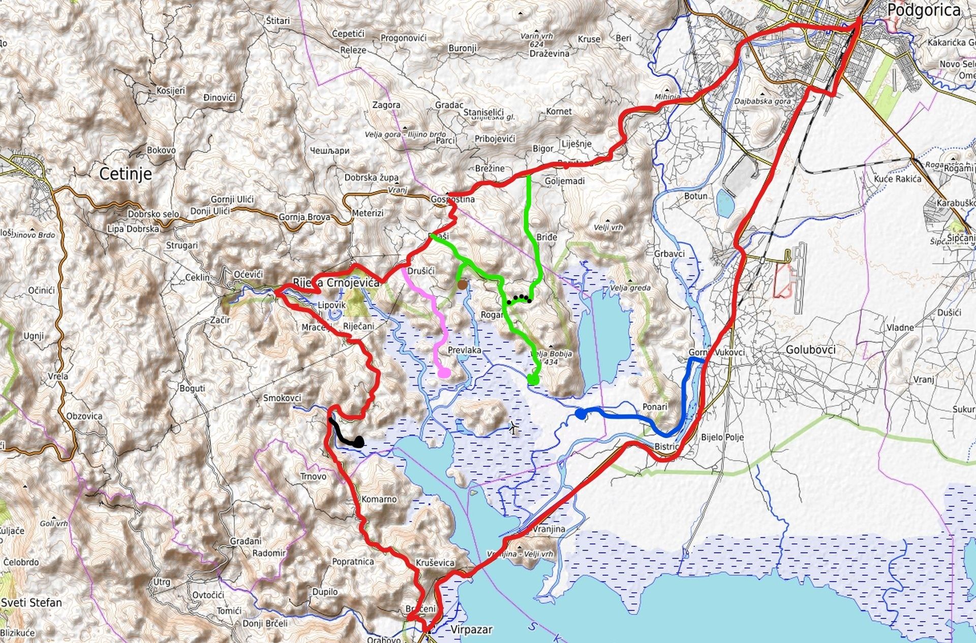
Map of the Route
RED line = round trip Podgorica-Virpazar-Rijeka Crnojevića-Podgorica (80 km); BLUE line and dot = Žabljak Crnojevića; BLACK line and dot = Poseljani; PINK line and dot = Prevlaka; GREEN line = detour to Karuč and Dodoši (BROWN dot = Karuč; GREEN dot = Dodoši; dotted line = macadam stretch).
Just wanted to stop and say thank you so much for sharing your experiences with us. Ever since moving to this beautiful country, I’ve enjoyed exploring so many of the routes you mention in your posts. Looking forward to this one! Best Wishes
Thank you for this post, great photos (as usual) and the very instructive map.
Thank you for your nice comments. I will soon publish an e-book with 21 road trips for adventurous travelers. I’ll keep you informed!
What a great idea! Please also comment on the quality (and width) of the suggested roads. It’s often difficult to tell from a map how bad a road really is.