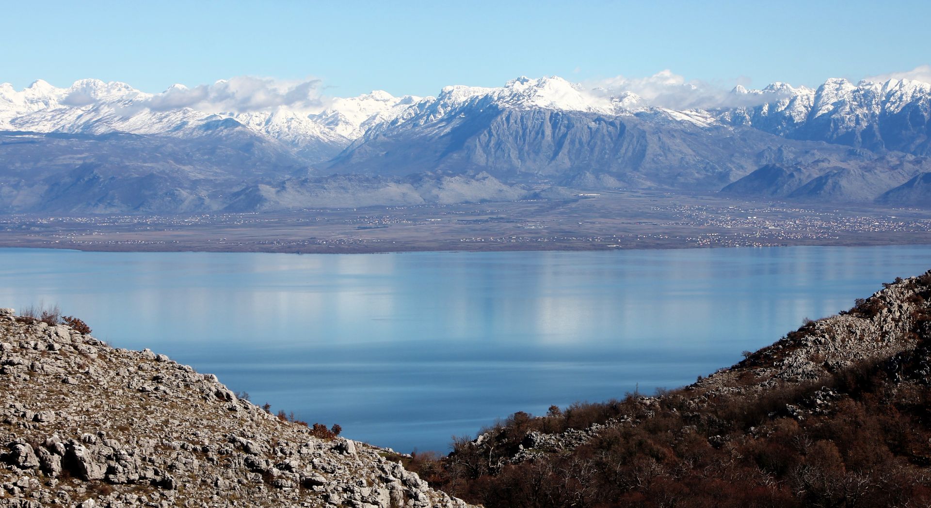
We have travelled many times along the western shore of Skadar Lake, from Virpazar to the Stegvaš pass, but we have never explored the villages of Gornji Šestani.
 Do you know where the Šestani area is situated? I am sure that many tourists, expats, and even locals, do not know that it is a sub-region within Skadarska Krajina, with villages that are scattered all over the mountain plateau above Skadar Lake and over the terraced slopes of Mount Rumija.
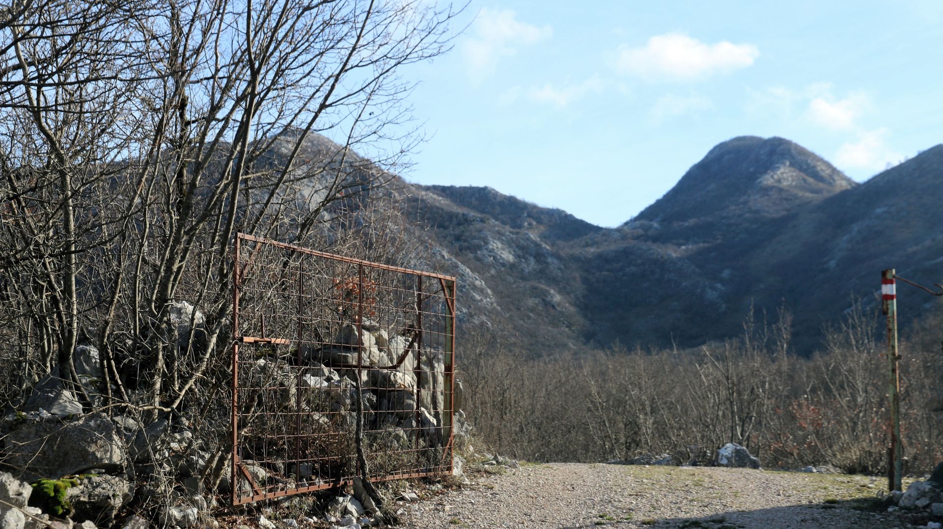
We had already tried to reach the villages of Gornji Šestani a few years ago, following a narrow road uphill somewhere between Virpazar and Murići. However, we didn’t know what to expect when we encountered an iron barrier that was blocking the road. Did it indicate that we were entering private property? Hard to say, there were no signs. Only later, we understood that such barriers are meant to prevent local cattle from getting lost.
 We returned home with the intention to gather detailed information about this region. On the internet, we learned more about the history and the people of Šestani. Obviously, some roads to the villages in Gornji Šestani had been paved in the meantime and so we got back last weekend for a new adventure.
But before I describe this fascinating tour, I would like to tell you something about the history of this region, which dates back to the 15th century.
History and legends
According to legend, the progenitor of Šestani, Zefa, originally lived in the Albanian area of Škrelj. As he killed his neighbour, he had to save himself from the blood feud by escaping to Shkodra. where he married. The blood feud was settled and he returned to his village in Škrelj. But as he committed another murder, he had to flee far away and he thus moved to Šestani with his family. He divided the land in this barren region among his six sons, who founded their own villages. Son Luka established Lukići (in Albanian: Lukaj), Deda founded Dedići or Dedaj, etc.
 The legend also says that the sins of old Zefa put a curse on his descendants, which says that they will never find peace in their own homeland and that they will always wander around.
A good example of the curse (or is it just the escape from harsh living conditions?) is given by the emigration waves in the beginning of the 18th century to the Zadar region in Croatia. This exodus was organized by Archbishop Vicko Zmajević of Zadar and it was supported by the Venetian Republic. It was their intention to repopulate the land around Zadar and to revitalize Dalmatia.
The ‘Arbanasi’ of Zadar are still speaking the Arbanas-Šestan language, a mixture of the Albanian ‘geg’ dialect, Italian and Croatian. They cherish their traditions and national costumes and they are very proud of their origin.
 In the 1960s and 1970s, many inhabitants of Šestani emigrated to Western Europe or overseas. Other villagers bought fertile land in the surroundings, e.g. along the shore of Skadar Lake or in the villages between Bar and Ulcinj. If often happened that one part of the family stayed ‘at home’, while other family members lived and worked on the new land. But there was another possibility: living in the home village during the summer – with the cattle – and moving to lower and warmer regions during the winter.
Time passed by and the development of Gornji Šestani was lagging behind. Nowadays, most villages of Gornji Šestani are ‘ghost villages’ with abandoned and dilapidated stone houses, often degraded to ruins.
Our road trip
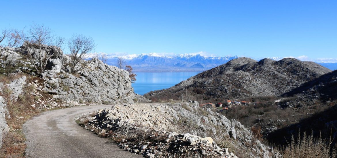
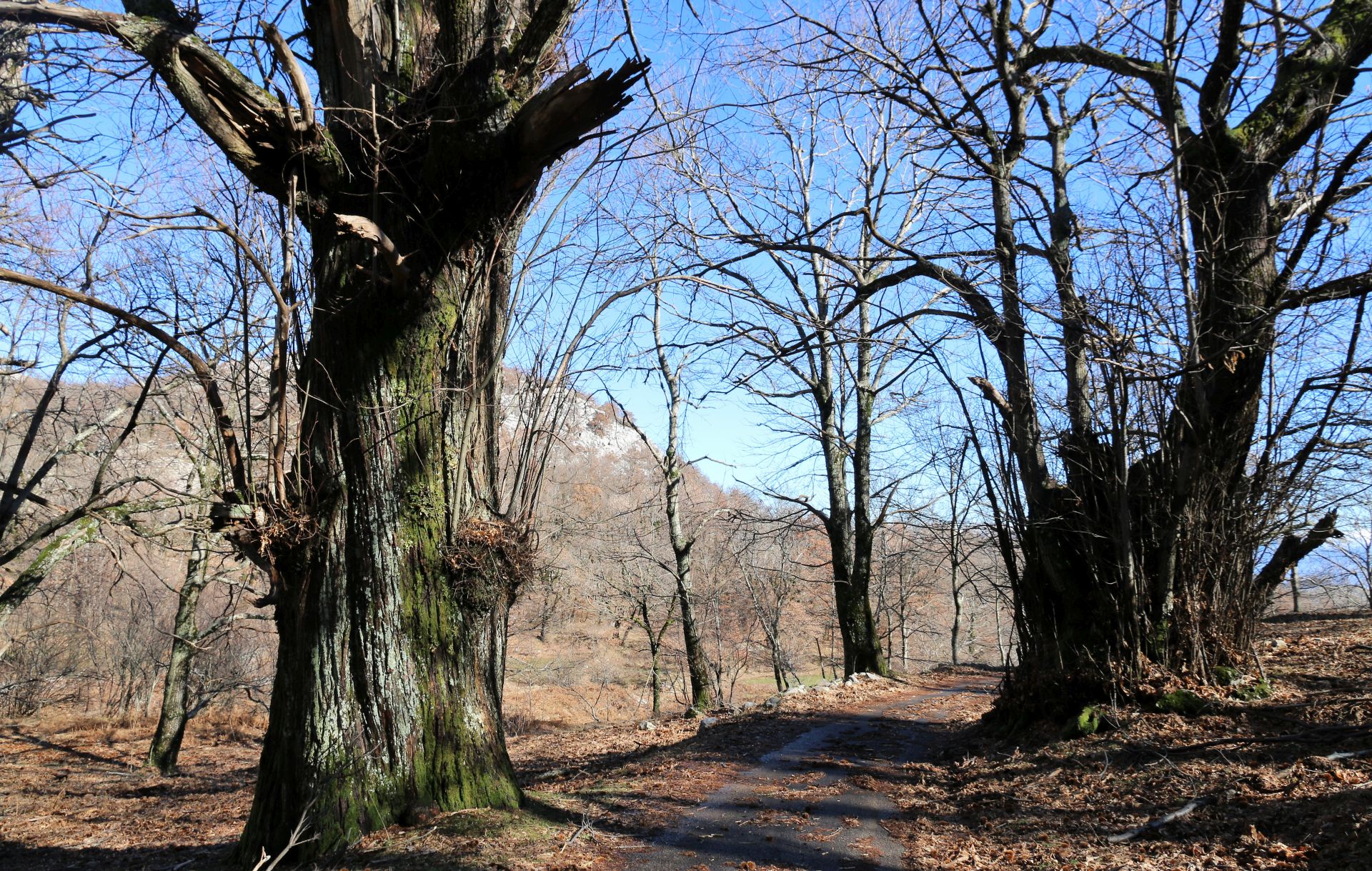 After driving from Virpazar along the western shore of Skadar Lake, we reached a junction above Donji Murići and followed the signpost ‘Gornji Murići’ uphill. The winding and narrow asphalt road without any protective railing (not recommended for people with fear of heights!) ran steeply uphill, passing through an extremely dry and harsh karst region, without water, without any sources and streams. The stone fields were covered with bushes and shrubbery, while fertile land could be found in ‘dolinas’ (sinkholes) only.
Behind the first hill top we saw a village with several renovated houses: Gornji Murići. A spooky deep gorge behind the village, which stretches all the way to Donji Murići, was almost dividing the mountain in two parts.
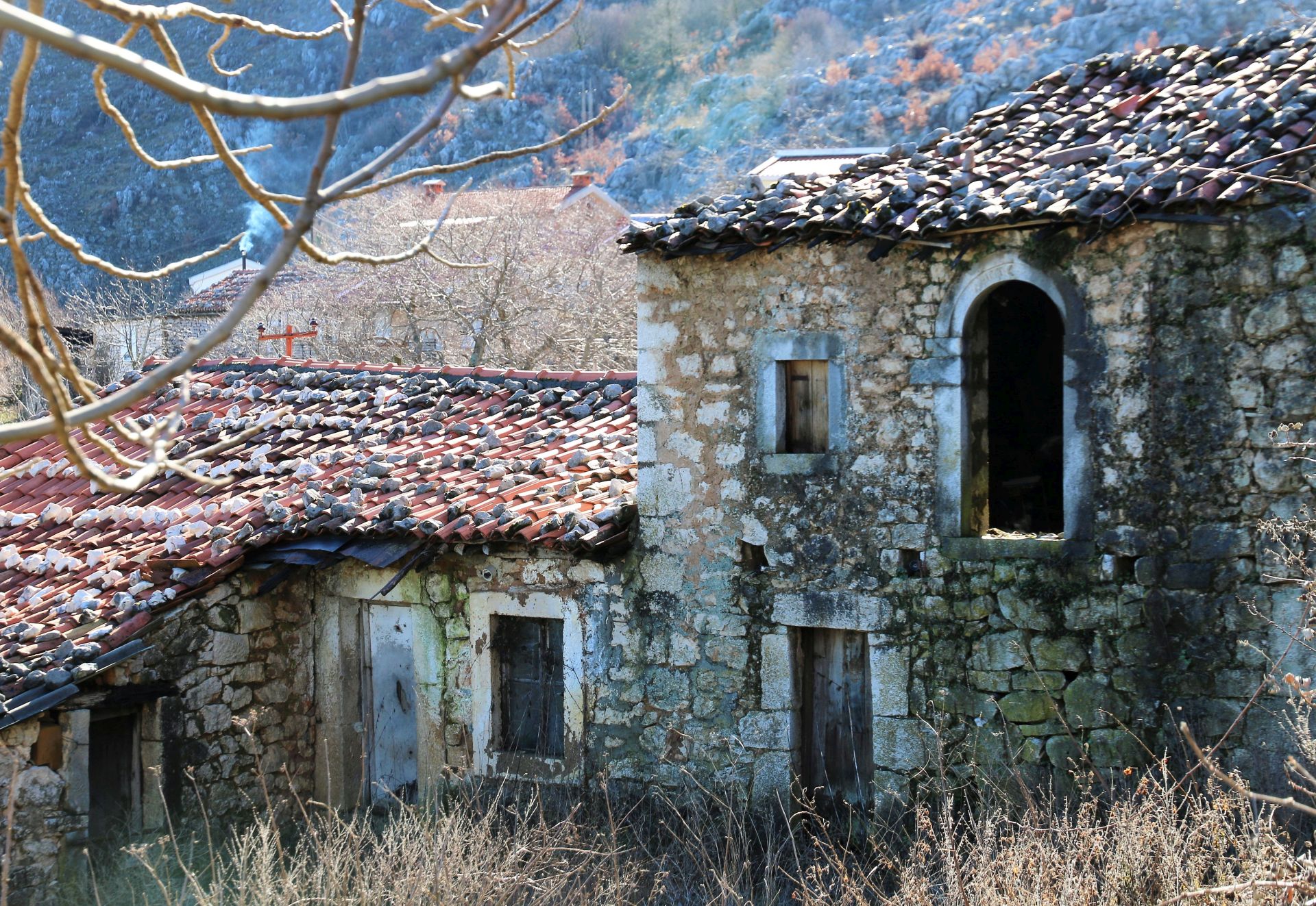
As we continued, we discovered the village of Pinčići. Village? As far as we could see, there was only one populated house and a lot of dilapidated stone buildings and ruins. Once, this must have been an attractive settlement with the typical architecture of the Skadar Lake basin.
Obviously, there is a hiking route to Mount Rumija passing through this village, as the road was freshly marked.
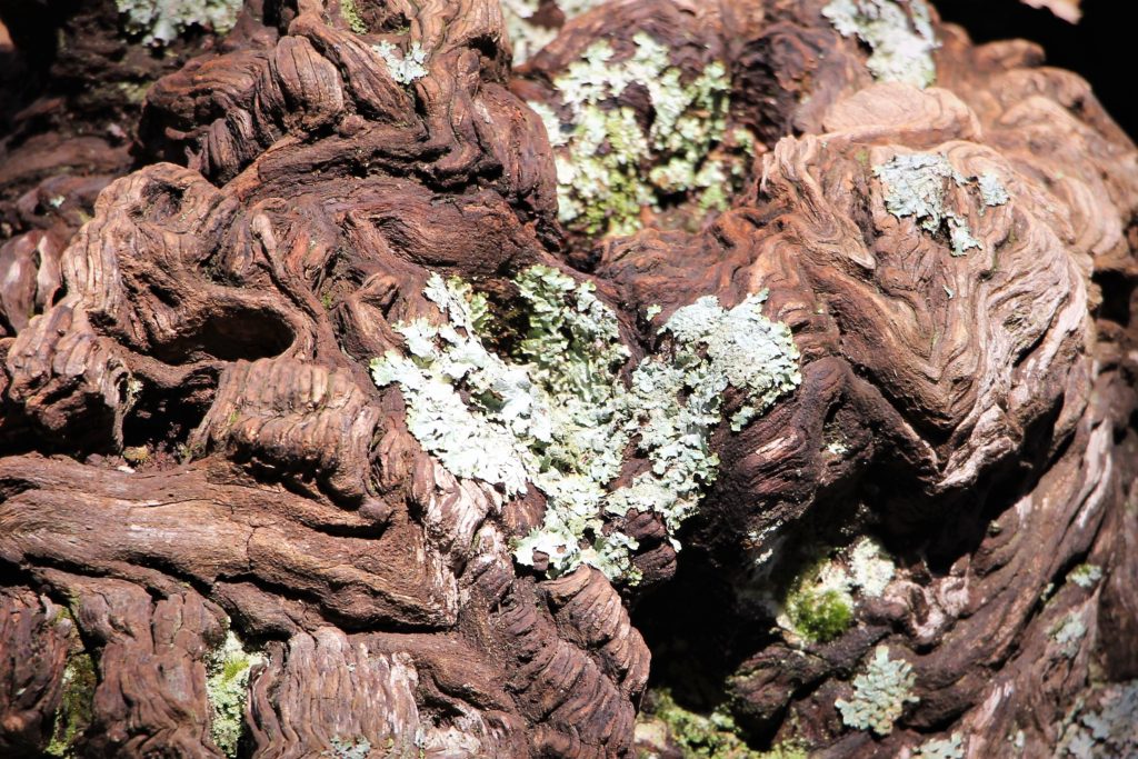
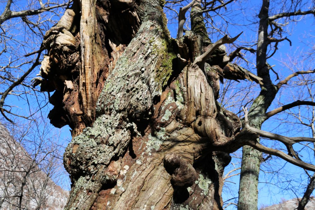
Roaming through the environment of Pinčići, in the direction of Repsa, we found a fantastic forest of chestnut trees (Castanea salitva Mill.). The centuries-old chestnut forests on the southern slopes of Mount Rumija and in Skadarska Krajina are under state protection. Some of them are up to 30 meters high with a diameter of 3 meters. They are very picturesque – sometimes you can discover true works of art on their huge trunk or branches. Good motifs for photographers!
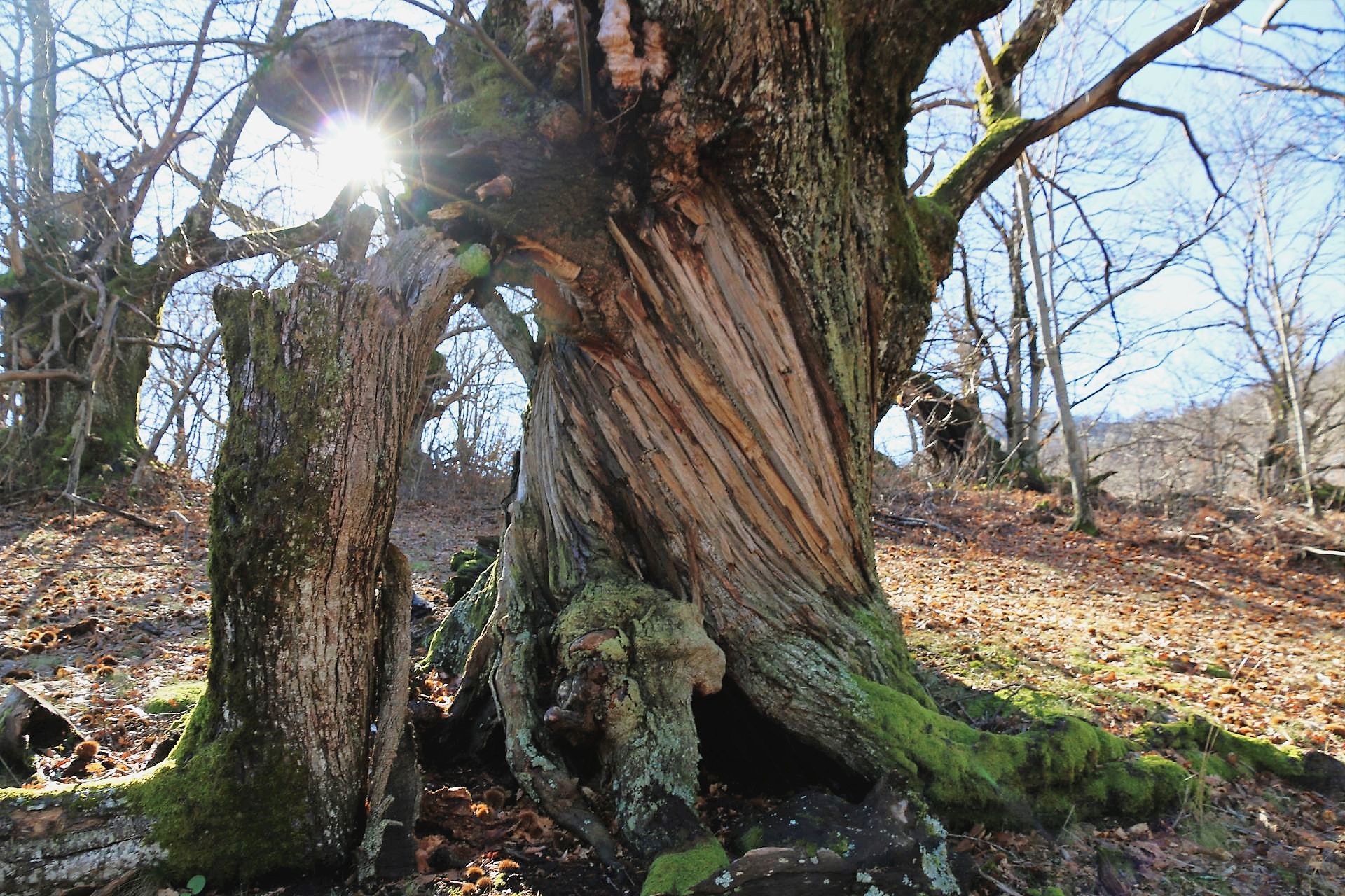 By the way, chestnuts represent a good source of income for the inhabitants of Skadarska Krajina, as they are also exported. And did you know that there is a movie called “I am from Krajina, the Land of Chestnuts” (2013)?
The road was covered with leaves and chestnut shells. By the traces we saw, it was clear that wild boars are frequent guests of these forests.
The road eventually turned into a narrow trail and we returned to the junction above Donji Murići, where we turned left and continued along the lake shore.
Seven kilometers further in the direction of Virpazar, we arrived at another junction, where we had to turn sharp left uphill. The signposts to Dedići, Lukići and Marvučići showed us the way. Also this road was narrow and steep, without any protective railing.
 This time, the iron barrier was open (we saw several other gates and barriers during our trip, probably indicating the territory of individual villages). Driving through a deserted and harsh karst region, here and there alternated with deep-green ‘dolinas’, we arrived at a junction without any signposts.
We turned right. According to the map, we should soon reach the village of Marvučići. The road became worse and turned into an off-road trail (also accessible for solid passenger cars).
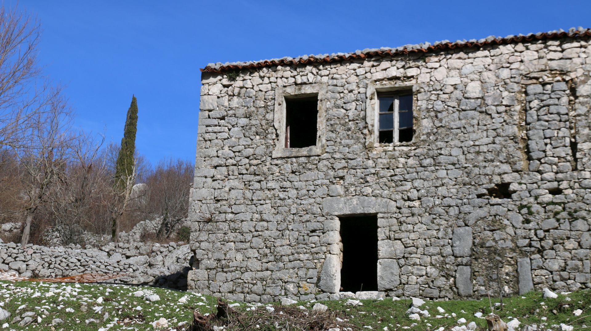
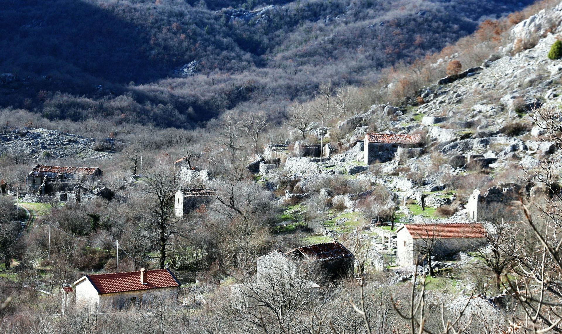
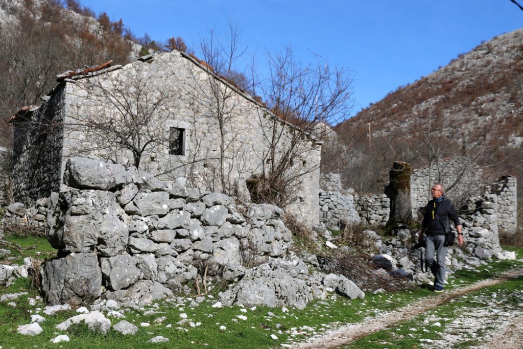
On the right side of the road we saw the remains of Marvučići, one of the oldest villages of Gornji Šestani that was founded three centuries ago. In those times, the ‘kula’ (defense tower) was surrounded by several impressive stone houses, but everything is abandoned and in ruins now.
When we parked our car, we met a lonely villager who had just arrived to check his property. The man was proud to show us a renovated two-storey house at the entrance of the village with a new concrete bell tower next to it – it was meant to be a new church (the inhabitants of Šestani are Catholic), while the ground floor of the building should be arranged as a local ethnographic museum.
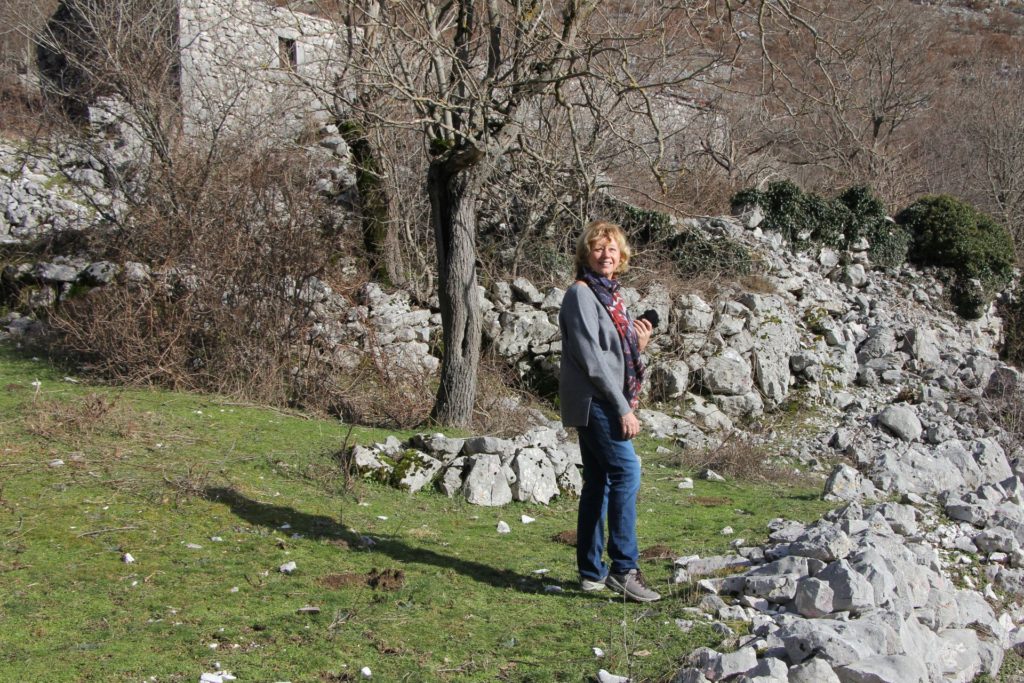
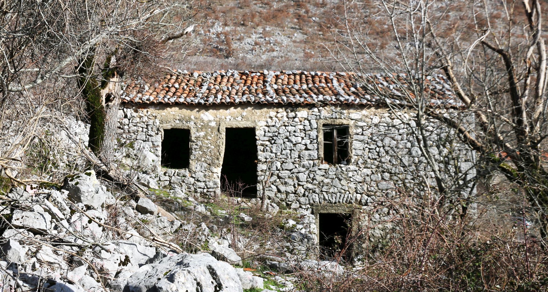 We took a walk through the village that must once have been the home of several hundreds of people. Now there were only two habitable houses, but we were told that people are more and more interested in renovating their homes and living here, at least during the summer. Gatherings and village festivals are organized, picnics and folklore performances are held, and life is expected to come back to Marvučići.
An important precondition for such a trend was the providing of electricity in this region, while it is also expected that several roads will be reconstructed and paved.
We were flabbergasted with the ‘ghost village’ of Marvučići. Is it possible that there still are such abandoned villages at a distance of 50 km from Podgorica?
 Walking through the village, in between old houses and stone walls, I tried to imagine how life looked like, a century ago. I can imagine that the only source of income was farming and cattle breeding, but could people survive in dry summers, could they provide for a good and comfortable life? Probably, one dry and infertile year would be enough to disturb the fragile balance, which makes it easy to understand why the population was often forced to move and find a new way of living.
But of course, there were also other reasons why people abandoned their home villages. First of all, there were (and often still are) no roads. Until recently, ancient horse trails were the only connection with Bar and Virpazar. According to oral folktales, these tracks have been used by thousands of people and horses traveling between Bar and Doclea in ancient times.
 Until recently, donkeys, horses and mules were the main means of transportation. But loads were also carried by women: it was their duty to bring their products to the markets of Virpazar and Stari Bar, a journey of around three hours.
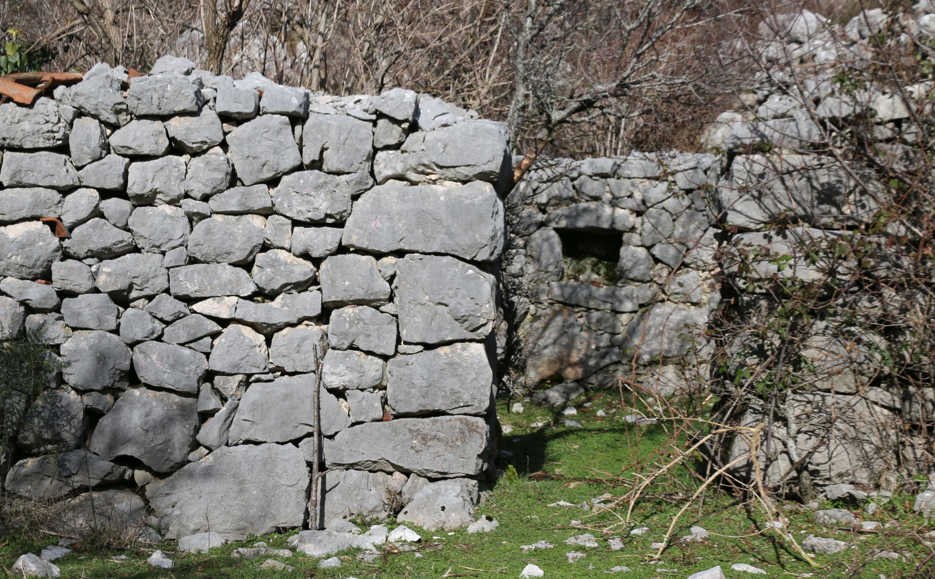
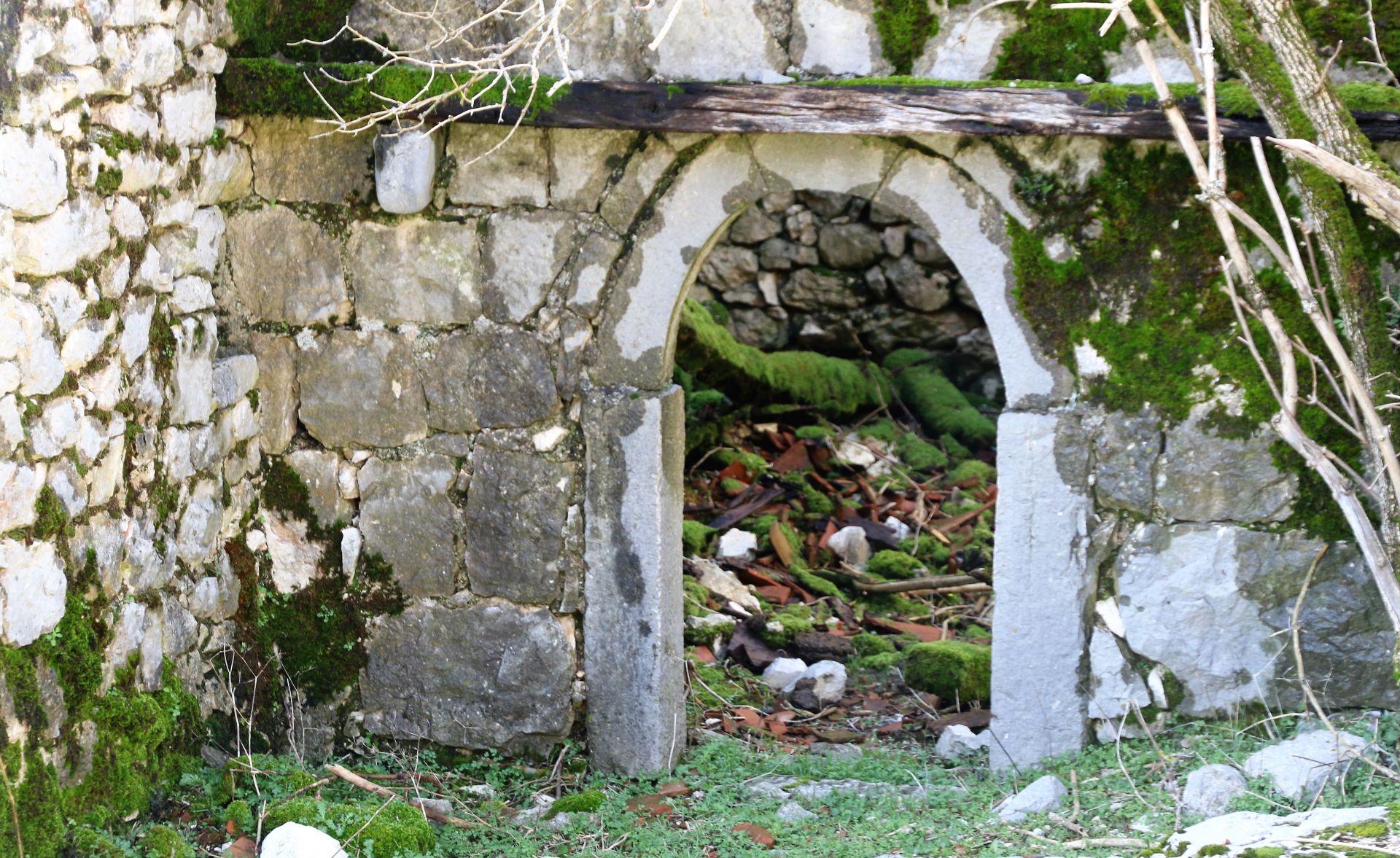
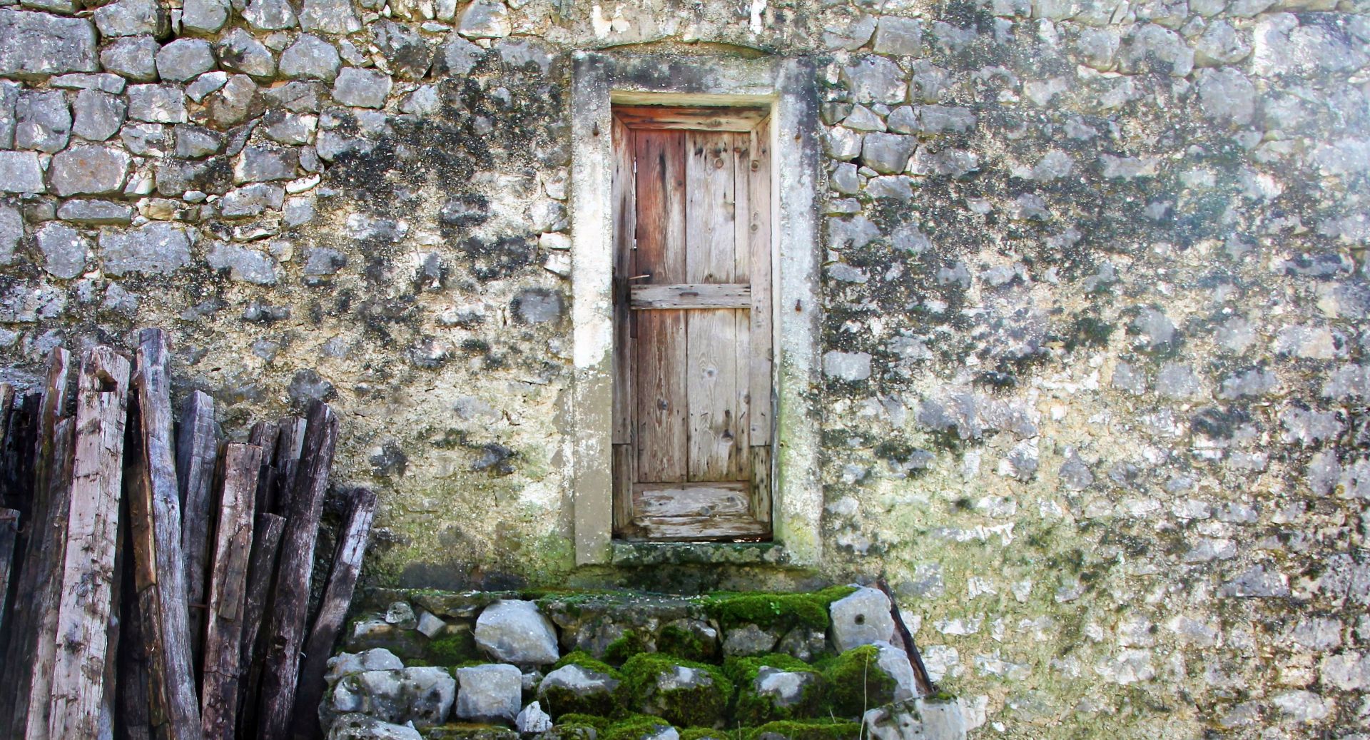
Roaming around the village, we admired the remains of the typical architecture of this region. Houses were often surrounded by strong dry stone walls with rounded corners. There were ground-floor houses (‘prizemljuše’), but also ‘houses on den’ (‘kuće na izbi’). These elongated houses often had one upper residential level, while the ground floor was used to house cattle and store dry goods (see https://issuu.com/svetislavpopovic/docs/arhitektonsko_nasljedje_basena_skad).
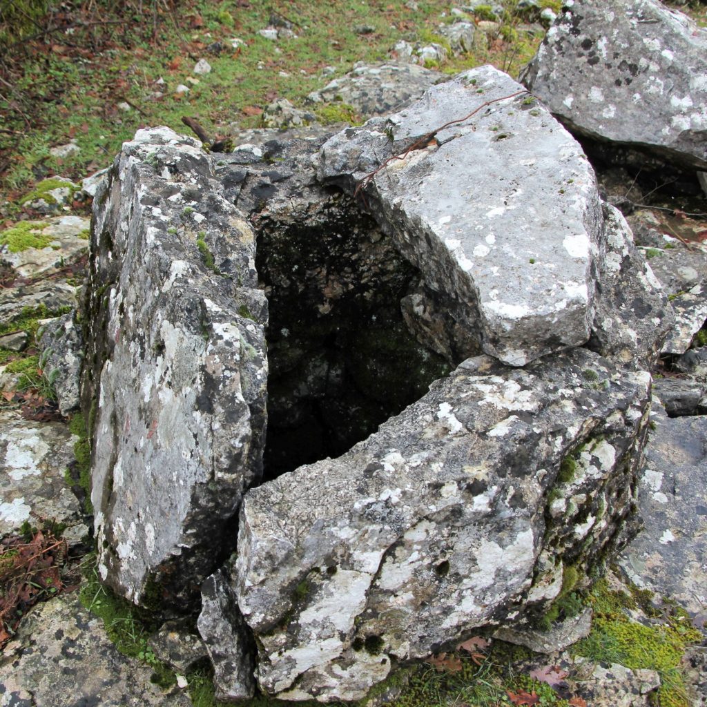
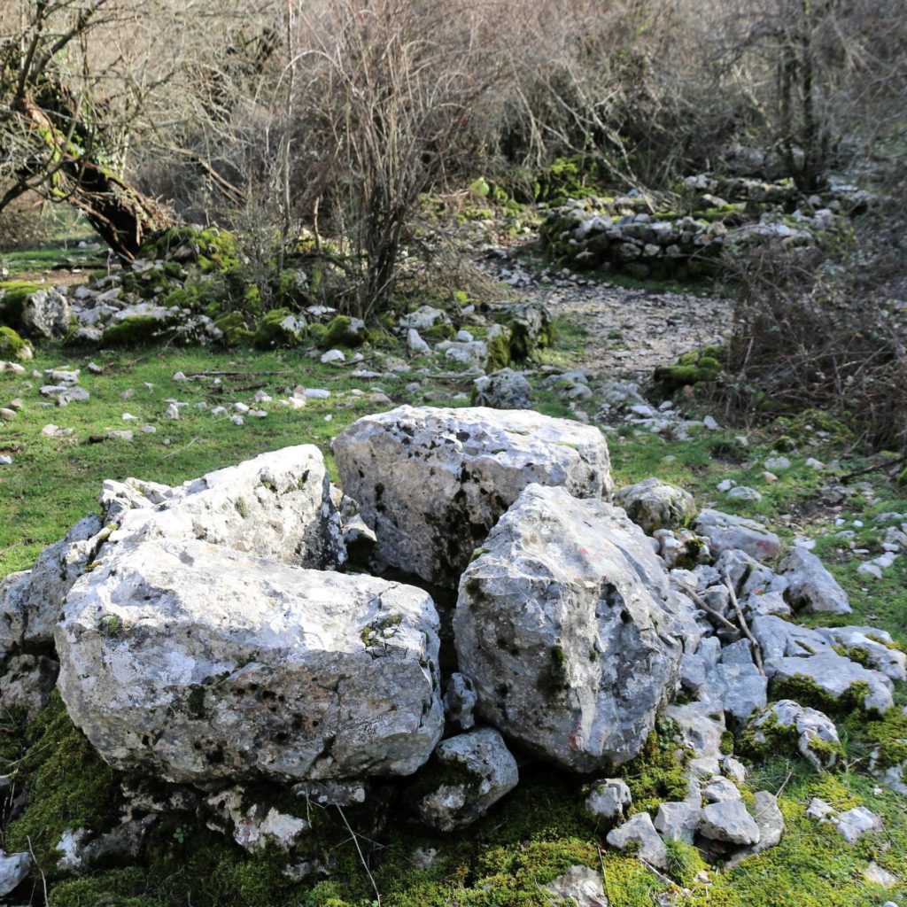
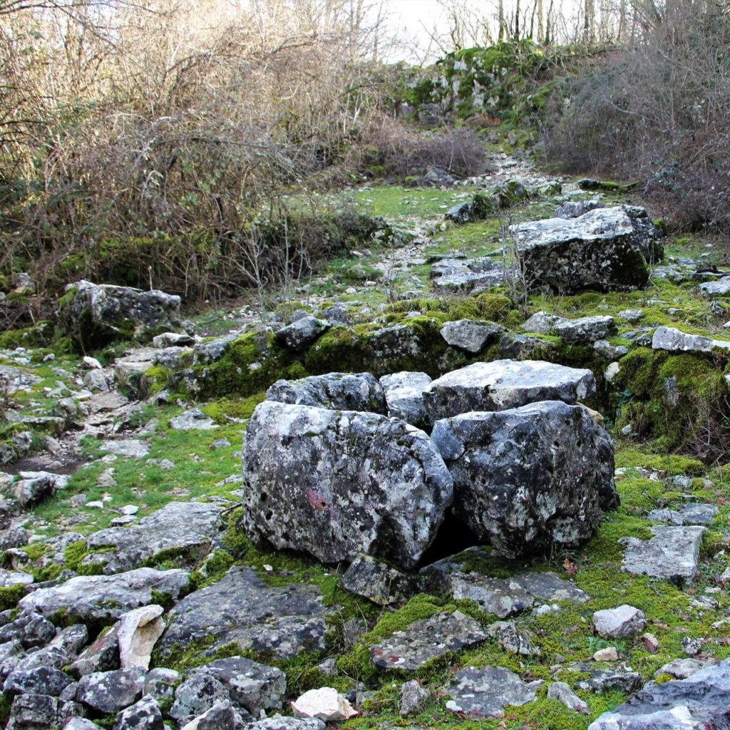
The villages of Šestani are also characterized by their ancient wells. As this karst region is extremely dry, each village used to have several wells, for each family one. They were of vital importance for the inhabitants, as there was never water enough in this rocky area without any sources or streams.
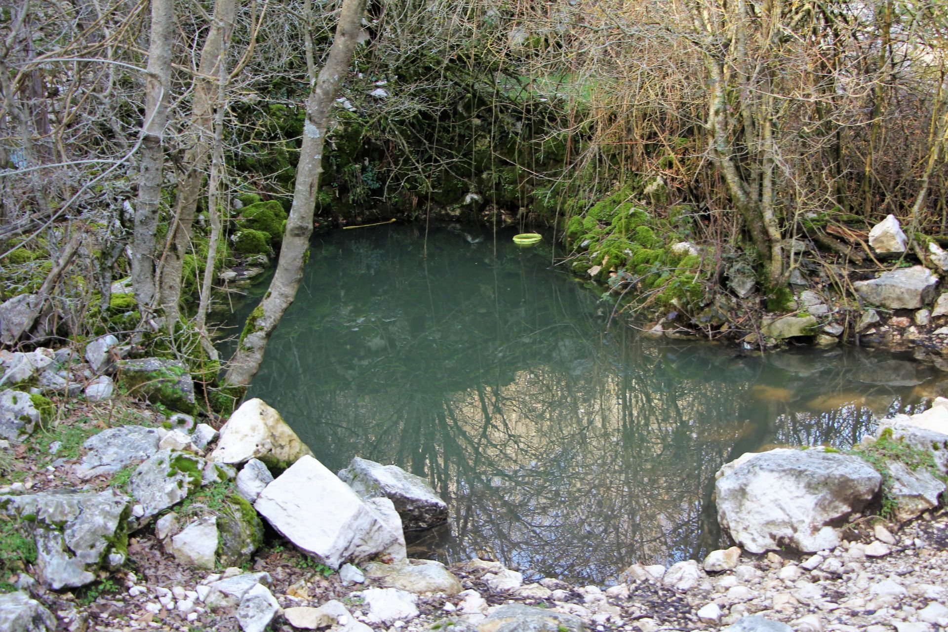 Earlier, we had already visited the wells of Boljevići and Livari, but now we had the possibility to see the ancient wells of Marvučići. We were grateful to the villager we met for explaining us how to reach them. And I am sure that few tourists have had such an interesting opportunity!
Driving the narrow and rather muddy forest trail was a bit of a challenge (if you don’t want to take risks, you can also walk). As we passed the village, we continued another 500 m and then reached a junction, where we parked the car. The trail to the wells continued on the right side, around 100-150 m downhill. Soon we discovered a dark and humid spot in the forest with a lot of big stones and a water pool, obviously a drinking place for cattle.
Just imagine how impressed we were when we discovered that these big stones were actually ancient wells! They had been made in a rather primitive way, but they still contained water. I tried to envisage how hard it must have been for the local women to carry their water to the village.
Why were these wells dug so far from the village? Well, it was important to find a suitable place for digging and the villagers knew that they would find water at a place, where wild pear trees grow. That was the only criterion!
 But what did they do in a dry year, when there was not enough water for the cattle? They took the cattle to Skadar Lake, a journey of around one hour. For drinking water, they had to go to Bijela Skala on the slopes of Mount Rumija, a mountain walk that lasted two hours.
No wonder that families from the villages of Gurza and Lukići were allowed to possess 70 pieces of small cattle (goats, sheep) only, as was stipulated by a law from 1934.
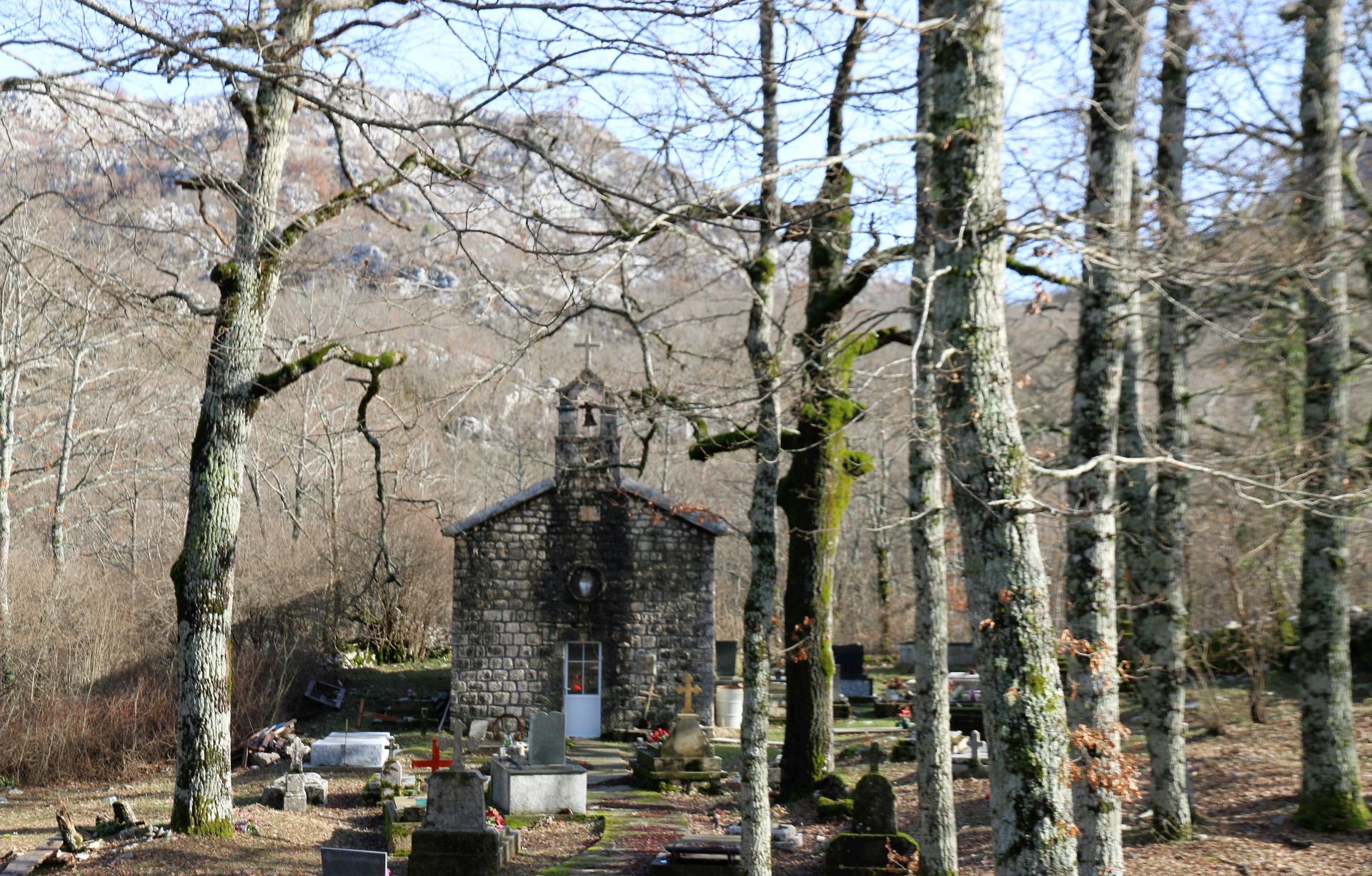
We left Marvučići and explored the surroundings, driving off-road trails. There was no sign of life in the forests we passed through. A stretch of new asphalt led to the church of Lukići, built in 1887 and renovated recently. This was the end of the road and we had to turn back to Skadar Lake and further to Virpazar.
With nostalgic feelings, we left Gornji Šestani, once a region with hundreds of inhabitants, now abandoned and populated by wolves, wild boars and eagles only….
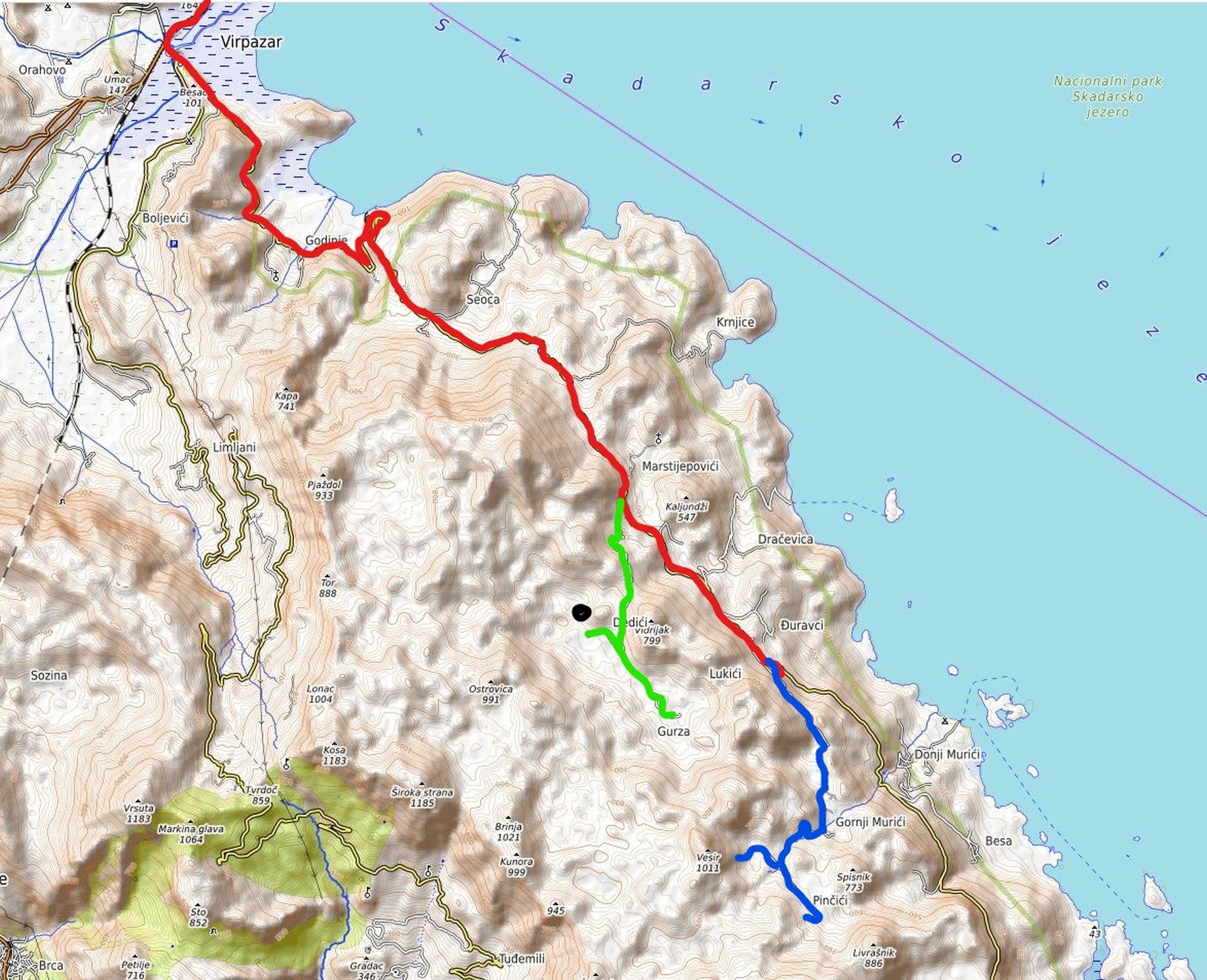
Map of the Route
The total distance Podgorica – Virpazar – Pinčići – Lukići – Virpazar – Podgorica = around 120 km.
Red line = road Virpazar – Ostros
Blue line = road to Gornji Murići and Pinčići
Green line = road to Marvučići and Lukići
Black dot = Marvučići
Interesting; good tip for our holiday in ME.
I love your blog as it always brings back fond memories of my trips to Montenegro. I look forward to making it back when it is safe to travel again.
I admire your adventurous spirit. Keep up the great work!
Thank you for another fascinating description of off the beaten track destinations in Montenegro. There really is no other comparable online travel guide (covering Montenegro). At least not in English. Would also like to commend you on the pictures. Very nice.
I really love maps and I would really like it if you could include a map of your destination.
This is amazing! You visited my family’s ancestral village 🙂 I got close to the gate in late 2019 but it was closed so it’s so brilliant to experience Marvucici through your blog! Cheers from New York City
Hi Paul, thank you for your nice message. Marvucici is one of the most interesting villages in Montenegro and I really hope that you will get the possibility to visit it in the near future! Jin regards, Marianne
Thank you for all the research! My ancestors are from Dobrec and migrated to Ulcinj. My (late) uncle’s magazine BUZUKU would be of interest to you. Warm regards from Vancouver, Canada.
I love going back to wild rocky beauty of Šestani! My wife’s family still has property in the abandoned villages of Dedići and Bardići. Her cousin has an active role in maintaining the church at Lukići…
I hear many tales of how hard life was living in Šestani from my inlaws, walking over the mountains in all weathers to market, to school, or tending goats. They now live in Australia.
I can recommend the wells as a great place to keep your beer cold! (just bring some string!).
Hello Marianne. I just came across your article and want to thank you for visiting Šestan and sharing your experience. Wow! As you could tell from my name I am a direct descendant of Marvučići that used to live up there. My great grandfather, grandfather and dad all lived up there and I actually slept in the old house about 20 years ago. I’m not sure if you got past the gate that says “Stop, privatan posjed” haha! But i believe the house is still pretty intact. I haven’t been in 10 years, while my grandfather was still alive. I was born and raised in Chicago, so I’m first generation American. My grandfather came to America in the 70s and dad shortly thereafter. Bizarre right?! I’ve been going to Montenegro since I was a little boy and love it dearly. Almost all Marvučići live in Bar now including us, our summer home. My great grandparents/grandparents/dad would bring the cattle down to the coastline in Kruče (Bar/Ulcinj border) where we still have land to this day. Your article has now encouraged me to learn even more about Šestancia, since I always used to talked about our past with my grandfather and my dad. This was an interesting read and thanks again. Where are you from if you don’t mind me asking?
Beautiful..only one thing…correct name of the chestnut in Latin is CASTANEA SATIVA,sativa meaning edible…🙂🖐
Thank you for the correction! 😊
My name is Djura (Gjura) Malevic (Maljevic or Malaj) and my father was born in Pici. My mother was in duravici (gjuric). We still own houses and land these. I’ve haven’t been there for awhile. Thank you telling this story it’s very much appreciated. ~ Djura
We were building a golf course in 2004 in Virpazar, we did actually build some holes all 18 and formed a driving range, then the government stopped us because there was a freshwater underground lake under the golf course which fed the coast, I went to the village up above Virpazar above the golf course, there was a spring there which supposedly healed anything, I remember putting my knee in the spring for about 5 minutes, it was swollen but wend down a day later and been perfectly since, in the derelict houses people had fled from during the earthquake of 1979, there were round stone areas in the garden, where the horse used to walk around to produce electricity, Wells for the water, the church was beautiful and all the gravestones were still there, the church was derelict when I went but still well intact, Montenegro is one of the most beautiful places in the world, I stayed for around four years in Bigova When my good friend Mr Bobo, who had done a nice development at his own House, the tourism there could be fantastic, and I would say the remains of our Golf Course in Virpazar Must be there, it is not really that cold in the winter either we also used to stay in Budva In the Fontana hotel, I believe it has been demolished now and Budva Is an amazing tourist place, we also lived there for around 12 months, I absolutely love the place, that was also someone at the time trying to build a golf course by Tivat Airport he was from Holland, in Budva We stayed in hotel Fontana with Mr Ubo His family and a hotel and bar on the lake Skadar at Virpazar, I actually went through the new tunnel between Virpazar And Bar before it opened, Absolutely wonderful days, I also remember Mr Ubo inviting us to an All Saints day in his hotel Fontana in November, fantastic. The hospitality was unbelievable, the wine is fantastic as well as it doesn’t make you poorly if you have too much, also the way they look after children in Montenegro is wonderful, we were there at the very beginning of English people and an English little boy got lost one day when we were in hotel Fontana and within five minutes, the police had brought him back to his mother and father, this country is beautiful very laid-back and the people are wonderful, when I was there, it was going back in time but beautiful Tony